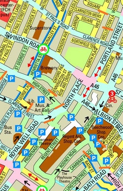
Cheltenham Cycle Map
The Cheltenham cycle map colour codes all roads, according to their friendliness for people riding bicycles. Reference is made to BikeAbility training levels as a guide as to the suitability of the road for particular cyclists.
Sample map area:

The map is based on the following principles:
- All roads (other than where cycling is legally prohibited) are cycle routes, but the amount of skill needed for using them varies according to traffic volume and speed and the complexity of road design. Whilst inexperienced cyclists will not be competent to use more difficult roads, almost all roads are capable of being used safely by cyclists that can attain the Level III National Cycle Training Standard.
- The map should have the widest audience and provide information useful to cyclists of all abilities. However, not all of the information will be relevant to all cyclists. By providing 'higher level' information, less able cyclists may be inspired to extend their horizons by becoming more skilled.
- Whilst designated cycle routes and other facilities are clearly shown, they should not dominate the map. Facilities of low standard, particularly where there are safety concerns, should generally be omitted.
- The map as a whole should provide a 'do-it-yourself' tool to enable any individual, irrespective of their ability, to work out the route that is best for them between any two places. No network of designated cycle routes can ever provide such a comprehensive asset for all cyclists.
The road colours are:
Yellow
Quiet roads with little traffic and low traffic speeds. Generally suitable for all cyclists. These are mostly non-distributor residential streets or roads through parks.
Green
Through routes with moderate traffic and low speeds. Suitable for Level II and Level III cyclists; perhaps Level I at less busy times. Shopping streets and industrial premises should be classified green as minimum due to the complexity of the traffic environment.
Blue
Busy roads, including A or B roads, where road design is traditional and does not lead to excessive speed. Few HGVs. Road width allows safe overtaking of cyclists over the greater part of its length. Suitable only for Level II and Level III cyclists.
Red
Busy principal roads, perhaps with some HGVs. Road width restricted, leading to increased risk from overtaking vehicles. Traffic speed high relative to road width with drivers less willing to cede right of way to cyclists. Complex junctions. Suitable for Level III cyclists and some Level II.
Purple
Fast, busy roads with frequent HGVs. Motor vehicle-orientated road design, such as use of slip roads, large roundabouts. Restricted lane width. Suitable only for Level III cyclists.